-
- Start with a City beginning with A
- This is BY STATE
- Similar to the Tag contest, there will be one thread per state
- Post a picture of your bike AND some sign, building etc which clearly shows the city/state you're in
- The next person posts from a city with the name beginning with B, then C, D, etc
- You can't posts back-to-back pics, you have to wait for a person to post the next city
- Once Z is reached, the game starts over with A
- If your state doesn't have a city beginning with the next letter in sequence, it's okay to skip that letter
- If the location sits for more than one month, the person that posted that is open to move it to the next letter.
The World Wide game is a bit different as it is by whatever is considered a geographic type of regional category, state/province/village etc. and all those will be in the single World Wide A-Z topic.
You are using an out of date browser. It may not display this or other websites correctly.
You should upgrade or use an alternative browser.
You should upgrade or use an alternative browser.
TN: A to Z (Round 6)
- Thread starter Mellow
- Start date
Uncle Phil
Site Supporter
Water Valley For W -

A little bit of history -
This was one of Maury County's first settlements, and the earliest marked grave (Sarah Fly, 1808) in the county lies here. In 1824, Water Valley had 61 voters and paid taxes on 14 slaves. Water Valley was known for its flooding waters of Leiper’s Creek often damaging homes and businesses in the area. The community was once known as Spencer’s Mill changed it’s name to Water Valley in 1874 when a post office was established here.
The Roundtree Brother’s Store established in 1892, and was originally owned by George Harlan and J.W. Oakley. Along side the Roundtree Brothers Store stood the McGowan Store known for the sale of handmade brooms, wild animal pelts, hair cuts, and hack service to Columbia. Frank Dodson owned the McGowan Store. At one point, it was moved by “four mules with a triple block and tackle, rolling it on logs, to turn the large building around to face Water Valley Road”. Large stock scales, peddling wagon, and gristmill was operated through the McGowan Store during Frank Dodson’s ownership. C.E. Dodson also purchased the Tom Humphrey Store, which was located two miles up Leiper’s Creek, and moved it next to the original store. Dodson ran this store until 1977. In 1891, Thomas Pigg gave an acre of land to build a non-denominational church which was also used as a school house. With the help of the county, and Donald Galloway, who helped in raising money, the town was able to build a four room school house in 1911 in which grades first through eighth were taught here. A graduation ceremony was held for all graduating eighth graders. Water Valley school was built in 1949 and two teachers taught grades one through six. In 1959, Water Valley school was closed and all the children from Water Valley began school at the Santa Fe School. A doctor’s office, dentist office, blacksmith shops all operated in Water Valley. The round roof just west of Leiper’s Creek signified R.P. Pigg’s general store constructed in 1896. The store burned around 1930. Cleve Alderson built a store in the early 1930’s in Water Valley close to R.P Pigg’s store. At point in it's history, the entire town was put up for sale. Here's that story -
WATER VALLEY, Tenn. — Nestled down a country road lined with sprawling fields and the occasional farmhouse is a defunct town called Water Valley. The tiny historical plot of the long-forgotten town core is for sale for $725,000. With that comes a barn, an apartment and four old stores, which were the lifeblood of the small country town near the Williamson-Maury county line. It's rural enough that the only sound you're likely to hear is the hum of cicadas, the bubbling of a fish-filled creek and maybe the quack of a nearby neighbor's duck. But it was once a bustling stop for the Middle Tennessee Railroad. The road that takes you to what's left of Water Valley lies on top of the old railroad bed.
Last edited:
Uncle Phil
Site Supporter
Uncle Phil
Site Supporter
Belfast for a B (happens to be in the county that I grew up in) -

A Bit of History -
A post office was established at Belfast in 1836.
The community was named after Belfast, in Northern Ireland.
The first commercial business in Belfast opened in 1838.
The depot at Belfast is considered the best surviving example
of the Duck River Valley Narrow Gauge Railroad buildings.
The small Victorian rail station is an excellent board and batten structure.
It was built before the 1870's.
The tracks have long since been removed.
Now, is on the National Register of Historic Places.
J. C. Tate General Merchandise Store is located there.
In 1878 Robert Williams built the store and warehouse.
Mr. and Mrs. Ed Tate operated the store; he was the great-great grandson of William Williams.
Five generations of the same family owned the business.
Three of these have operated the store in the present building.
This is the oldest commercial building in the Belfast area and the oldest business in the county.
Over the years the store had stocked patent medicines; food and yard goods; agricultural
implements, supplies, and seed; and coffin handles.
Farmers sold their turkeys and feathers, country butter, and animal pelts, and could obtain crop loans here.
The town's post office was for many years located in the building.
It was occasionally a polling place
It closed in 1990 after 112 years in business.
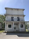

(C)arthage The Cordell Hull bridge is open decades of being closed. No good place to stop and take a pic.
![20240722_134132[1].jpg 20240722_134132[1].jpg](https://www.st-owners.com/forums/data/attachments/205/205492-568381a79d8c104d5401d507b51a957c.jpg)
![20240722_134132[1].jpg 20240722_134132[1].jpg](https://www.st-owners.com/forums/data/attachments/205/205492-568381a79d8c104d5401d507b51a957c.jpg)
Last edited:
Uncle Phil
Site Supporter
(E)lmwood
- Elmwood is an unincorporated community located in Smith County, Tennessee, United States. Its ZIP code is 385601. The area is known for the Elmwood Mine, which has been an iconic site for zinc mining and the production of extraordinary mineral specimens2. According to the 2020 U.S. Census, there are approximately 1,309 people residing in Elmwood.

Uncle Phil
Site Supporter
SmashVol
Site Supporter
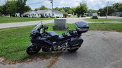
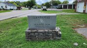
Granville-G
You’ll find Granville an hour east of Nashville, nestled on the banks of the Cumberland River. From the early 1800s until 1920, Granville was a thriving riverboat town and farming area. However, by the mid-1900s, when the Cordell Hull Dam was built, much of the once profitable farmland was buried underwater. Residents left to find better economic opportunities, and Granville became a near ghost town.
Around the year 2000, a group of volunteers united with the vision of making Granville a destination city and preserving the story of this riverboat farming community. It’s a testament to the town’s southern hospitality that this committed force of 200 volunteers maintains the town’s operations and its many museums.
Early settlement but has deep roots with the local Native American tribes due to the river going around the town which was dammed up by the Cordell Hull Dam and now is a peninsula in the lake with the same name as the dam.


Uncle Phil
Site Supporter
SmashVol
Site Supporter
Uncle Phil
Site Supporter
Joelton for J (a short hop for me) -

Joelton was settled principally by German, Scots-Irish, and Italian immigrants. Agriculture through small family farms on fertile lands and subsistence farming in the hills forged the economic backbone of the community until the 1920s. It sits above the “Devil’s Elbow” — a steep, curvy stretch of road that skirts between a cliff and a wooded ravine. Ghosts have been sighted here, according to Nashville Haunted Handbook. At one time it was called Paradise Ridge. The ridge was named after two brothers named Paradise and a 1909 newspaper account described the place as having a “lawless environment.” It became Joelton when the post office was named after Joel Griffin.

Joelton was settled principally by German, Scots-Irish, and Italian immigrants. Agriculture through small family farms on fertile lands and subsistence farming in the hills forged the economic backbone of the community until the 1920s. It sits above the “Devil’s Elbow” — a steep, curvy stretch of road that skirts between a cliff and a wooded ravine. Ghosts have been sighted here, according to Nashville Haunted Handbook. At one time it was called Paradise Ridge. The ridge was named after two brothers named Paradise and a 1909 newspaper account described the place as having a “lawless environment.” It became Joelton when the post office was named after Joel Griffin.
(K)irkland, Tennessee, is an unincorporated community located in Williamson County. It’s situated on U.S. Route 31A and U.S. Route 41A, about 14 miles southeast of Franklin1. The community is part of the Central Time Zone and has an elevation of approximately 745 feet (227 meters)1.
Hate to repeat, but options limited sometimes.

Hate to repeat, but options limited sometimes.

Uncle Phil
Site Supporter
(M)ilton
is an unincorporated community in Rutherford County, Tennessee, United States.[1] Its ZIP Code is 37118.[2] The community is concentrated in the northeast corner of the county along State Route 96 (Lascassas Pike) between Auburntown and Murfreesboro.
Milton was established by early-19th-century entrepreneur Gideon Thompson in 1820.[3]

Uncle Phil
Site Supporter
Neptune For N -
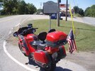


A bit of interesting history from the marker -


A bit of interesting history from the marker -
Pioneer settlers arrived in the area from No. & So. Carolina as early as 1808. Civil War soldiers camped here on their way to Clarksville & Nashville. The community was named when a post office opened in 1882. In 1883 the village had blacksmith shops, grist & saw mill, general store, school, Methodist & Baptist churches, Doddsville Tenn. Central RR station. Hagewood's Ferry on the Cumberland River operated until 1958.
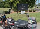
(O)ak Hill
This little trip in Nashville reminded me of everything I dislike about urban riding. I didn't have any trouble and the Scrambler is an excellent urban weapon. Still...
Oak Hill mansion (governor's residence) is in Oak Hill and I thought I'd have a chance to take a pic. The tall fence and closed gate squashed that idea.
Lots of big church buildings: I don't think the entire population of Oak Hill would fill them.

Last edited:
Uncle Phil
Site Supporter
Pinewood For P -


The story of Pinewood is both amazing and sad -
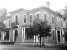
It was under Graham’s foresight and determination that Pinewood came into its own as a self-sustained village with rows of houses, a brick factory, a textile mill, sawmill, blacksmith shop, a canning factory, along with a grist mill that ground flour and meal. Included in this progressive community of more than four hundred was a hotel, general store, post office, a church, a school, and the Grahams’ Pinewood Mansion. Completed in 1868 the Pinewood Mansion cost an exorbitant $32,000 to construct. Unlike anything ever seen in Hickman County, the home boasted elaborate Italian plaster work and solar heated water. The bathtub was copper, the basin was marble, and the faucets were silver. But the feature most remembered by all who entered was the grand winding stairway, hand carved of Cuban mahogany.
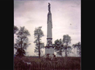
The tallest monument in Hickman County is the granite grave marker for Frances Helm Graham. Requiring eighteen mules to haul from Dickson, the marker still stands in the center of the Graham Cemetery on the Pinewood Farm. Mrs. Graham died in 1863. Mr. Graham died in 1892.
Son, John Graham suffered financial crisis in the early 1900s and sold much of the land. The land fell to different ownership through the years with Mack Craig purchasing the mansion and surrounding forty acres in 1967. Mr. Craig restored the house and filled it with antiques. In 1971 the Pinewood Mansion was added to the roster of the National Registry of Historic Places. In March of 1975 a fire started in the kitchen, burning the mansion to the ground.
At the time of his death, Mr. Graham owned over 6,000 acres, oversaw a self-sufficient community with its own currency and was the wealthiest man for many miles in any direction. Now all that is left of his 'empire' is a lonely grave marker that sets out in the middle of a field that can hardly be seen from Highway 48.


The story of Pinewood is both amazing and sad -
In the north central part of Hickman County is the community of Pinewood. Mrs. Samuel (Frances) Graham named the community from the fact that the original buildings were all constructed of pine. Settled in 1806 by James Davis, by 1820 there was a grist mill and cotton gin. It was in 1848 that Samuel L. Graham, with his brother Richard Graham and brother-in-law, William Lytle purchased the Davis farm and sixty five acres of land on Piney River. Samuel L. Graham and his son, John, came to solely own the land and kept buying until they owned sixty five hundred acres of rich farm land.It was under Graham’s foresight and determination that Pinewood came into its own as a self-sustained village with rows of houses, a brick factory, a textile mill, sawmill, blacksmith shop, a canning factory, along with a grist mill that ground flour and meal. Included in this progressive community of more than four hundred was a hotel, general store, post office, a church, a school, and the Grahams’ Pinewood Mansion. Completed in 1868 the Pinewood Mansion cost an exorbitant $32,000 to construct. Unlike anything ever seen in Hickman County, the home boasted elaborate Italian plaster work and solar heated water. The bathtub was copper, the basin was marble, and the faucets were silver. But the feature most remembered by all who entered was the grand winding stairway, hand carved of Cuban mahogany.

The tallest monument in Hickman County is the granite grave marker for Frances Helm Graham. Requiring eighteen mules to haul from Dickson, the marker still stands in the center of the Graham Cemetery on the Pinewood Farm. Mrs. Graham died in 1863. Mr. Graham died in 1892.

Son, John Graham suffered financial crisis in the early 1900s and sold much of the land. The land fell to different ownership through the years with Mack Craig purchasing the mansion and surrounding forty acres in 1967. Mr. Craig restored the house and filled it with antiques. In 1971 the Pinewood Mansion was added to the roster of the National Registry of Historic Places. In March of 1975 a fire started in the kitchen, burning the mansion to the ground.
At the time of his death, Mr. Graham owned over 6,000 acres, oversaw a self-sufficient community with its own currency and was the wealthiest man for many miles in any direction. Now all that is left of his 'empire' is a lonely grave marker that sets out in the middle of a field that can hardly be seen from Highway 48.

Attachments
Last edited:
Share:

![20240523_123431[1].jpg 20240523_123431[1].jpg](https://www.st-owners.com/forums/data/attachments/200/200936-22b21fa322b26c6c27df07055e5d8e14.jpg)
![20240627_125929[1].jpg 20240627_125929[1].jpg](https://www.st-owners.com/forums/data/attachments/203/203513-d9f2ee0b6e4839a4f8457a412600bfb5.jpg)

![20240717_102144[1].jpg 20240717_102144[1].jpg](https://www.st-owners.com/forums/data/attachments/205/205162-fbc2067d035558eac6806ea2055953b0.jpg)


